History
Heligoland didn't always have been an island. Until 5000 B.C. Heligoland was a part of the mainland and little sandstone and limestone mountains. The sea-level lay more deeply than today at that time and Heligoland was connected to the German mainland by a land bridge. Only 5000 B.C. Heligoland became an island, the land bridge broke by the increasing sea-level. Heligoland was already settled in the neolithic age, one has also found megalithic graves allegedly in Heligoland.
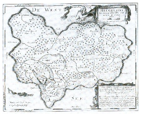
In 800 AD Heligoland was approximately as large as today El Hierro, the smallest island of the Canary Islands. There are scientists, who have the opinion that Heligoland could have been the legendary Atlantis. This is partly justifiable, Heligoland has its name from the old Friesian language, in the old Friesian language Heligoland was called the "Sacred Land". Without doubt Heligoland is one of the most beautiful German islands.
However, the geographical history of the island is ancient. The sandstone cliffs and the mussel limestone and chalk cliff arose 250 millions of years ago. Approx. 50 millions of years ago, the rocks were pushed up at an angle by a rock salt stick which lies under this.
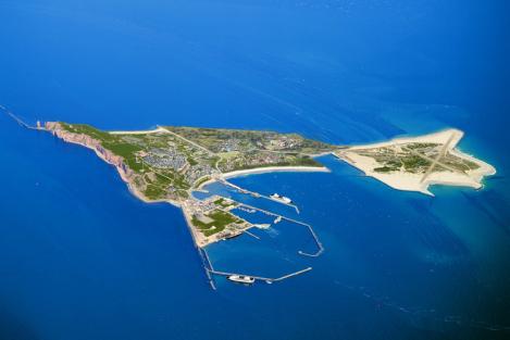
Heligoland was a double island till about 300 years ago, the red rock island was connected with the dune by a land bridge, which was called the Woal. The dune had the Witte Cliff and the was also much larger as today. The Witte Cliff consisted of mussel limestone and chalk and was also as approximately so tall as the red sandstone cliffs. Unfortunately, the Witte Cliff was used improperly as a quarry, one wasn't conscious at that time that this could have bad consequences. Protection of historical monuments and conservation laws were unknown at that time. The Witte Cliff was destroyed considerably by a devastating storm flood in the night of New Year's Eve 1710/11 and more once morely worse storm flood destroyed the Woal in the night of New Year's Eve 1721/22 and also gave the Witte Cliff the rest one. The Woal was broken through and disappeared gradually by the tides influence. At that time, unfortunately, one wasn't technically so far yet to protect the double island and the Woal with concrete walls, concrete dams and dykes. Heligoland was as today 4 times as big before these two storm flood disasters. "Exotics" even would have more place there, also on the dune and on the Woal themselves. The main island is more than a square kilometer large and the dune 0.7 square kilometers today. Today the Witte Cliff is not to see anymore, is hidden as a base under the dune.
One feared in 1850 that Heligoland could completely disappear of the map by the North Sea gnawing off at the red sandstone cliff within one hundred years. So that one took up lifesaving measures for the beautiful island, in this one set up concrete protecting walls, the so-called Prussia wall, which protects the west coast of the red rock island. So the rocks of the island are protected against the North Sea. But Long Anna, the emblem of Heligoland, is collapse endangered. One has kept Long Anna with concrete injections and sandstone colored concrete pedestals against the fast collapse, however, further new measures are necessary, approximately further concrete injections and extensions and reinforcements of the Prussia wall and stabilization measures of whole Long Anna (presumably Long Anna should be wrapped by one green build net for the duration of the stabilization meassures). But this costs millions of euro, one tries to get the necessary money by donations together now.
Heligoland has also a varied political history. Repeatedly Heligoland changed its state membership, was part of Denmark, of the United Kingdoms and of Germany. Allegedly shall Germany have got Heligoland directly in the exchange against Sansibar through one contract with the U. K. back. Object of the contract, however, wasn't the exchange of Sansibar against Heligoland as can be heard to this day again and again. It regulated rather comprehensively the German and English influence areas in Africa. Sansibar and its side islands were an independent sultanate at that time.The Germans had, however, leased unite a narrow stripe mainland coast of Sansibar and saw themself as a protecting power. The brits took on this position with the contract. With the contract the Germans wanted to have a good contact with the Englishmen. The Englishmen have handed over Heligoland to Germany only as a countermove because they wanted to get loose Heligoland since Heligoland was only a "seaside resort of the Germans" and was rather uninteresting for the U. K. In 1890 became Heligoland German again.
Hitler wanted to extend Heligoland to a submarine and navy port and extend the two islands, they should get the 15-fold area, this was the "Lobster Claws Project". The construction work was set for the duration of 30 years, but it couldn't be taken to end. One had started with depositing, so that the today's Northeast Area was arised and the Dune was enlarged considerably. Heligoland, however, got a far branched bunker system, which still has to be sightsee today. In 1945 the Englishmen occupied Heligoland once more and wanted to destroy the island completely or sink it into the North Sea, they made one of the biggest non-nuclear blowing-ups of all times in 1947, the BIG BANG, the Medium Land also arose and you see bomb funnels certainly on the uplands today. The island was of tough nature, came through. Worldwide protests of well-known politicians and of exile Heligolandians were the reason that Germany got the island back in 1952 and already soon the exile islanders returned to their island. Heligoland has a population of about 1,700 inhabitants today.
Now are new plans existing to enlarge the island. In April 2008 the first concretely plans of the known contractor and Heligolandian hotel owner Arne Weber to reunify the main island with the Dune were published. His plans envision one connection between the Middle Land with the Western Beach of the Dune by one 1000 metres long ferroconcrete wall, named the New Woal. The ferroconcrete construction will be anchored in the rock base of the island directly and could have a solid foothold. The actually land enlargement will be made by the flushi ships which will fill the only few metres deep estuary between the main island and the Dune with sand from the North Sea.
One feasiblity study of the plans of the Technical University Hamburg-Harburg and the Alfred Wagner Institute with the Biological Institute of Heligoland was made and noticed that the plans are absolutely realizeable. According of the study they could be realized within two years for 80 millions euros.
After the termination of the works more than 100 hectares of land will be available, so that Heligoland will be one square kilometre larger. As result the consisting runway will be extended and will provide place for bigger line and charter planes. On the top of everything one cruise terminal is planned in the harbor. The ships could dock in the new bay directly, and the outboating could be cancelled. By the drop of the navigable water between the main island and the Dune the nature reserve could be enlarged by 5 square kilometres surface of the water more.
Thereby one tide power station, two wind power processors and one solar energy field will be built with the land extension, these will make the island energy technically autarchic. The current power station which is running by diesel and products approximately 6 megawatts power for the island would then be redundant, because the diesel becomes more and more expensiver and becomes slowly too expensive. These new power stations will make Heligoland independent of oil and gas, this will be good for the finances of the inhabitants.
Also Arne Weber found support by the Schleswig-Holsteinian minister of enconomy Dietrich Austermann for his plans, but Kiel self will not finance the implementation of the plans, the project will be financed privately. Whether the Heligolandian island population does agree the plans, it's still uncertain, the opinions are very different, they reach from "This is a nonsense completely" to "Finally one reasonably idea". If nothing historical, economial and politcal intervenes, then the works will already begin in 2010 and be finished in 2012. The enlargement of the island would give new chances for our project, the "exotics" will get more places on the island, they could stand in the gardens and parks of the New Woal.
Heligoland in 800 AD - Approximately as large as El Hierro today! Here you see the further development of Heligoland, left below the size of the island in 1300, inside there also the island size in 1649. That Heligoland unfortunately got smaller and smaller, it was the increasing sea-level and today's coastal preservation technology still being missing at that time.
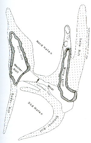
Heligoland in 1649 as double island with the Woal (center) and the Witte Cliff (right)
Lobster Claws Project Heligoland Hitler Age 1933 - 1945
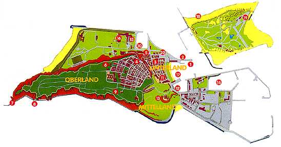
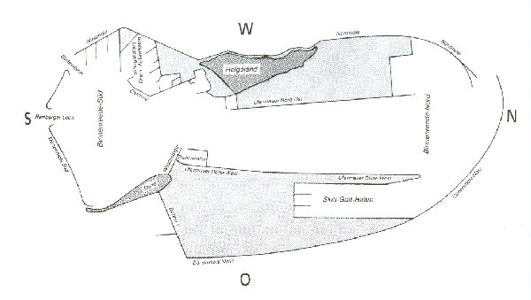
Heligoland and Dune in their shape today (Map)
The future of the island: Heligoland and Dune reunited
Author: Joachim Jaeck
Updated on July, 21st, 2008